'Hurricane' Schwartz: Winter (briefly) returns
Yup, it’s March, and we often see wild swings in weather over just a couple of days.
FROM 60S TO SNOW
Yup, it's March, and we often see wild swings in weather over just a couple of days. We had three straight days with highs up to 64 degrees, but wind chills dropped to 31 degrees Wednesday afternoon. So, it felt 33 degrees colder than just 24 hours before!
Wonder why it felt extra cold?
Well, our bodies got fooled into thinking it was spring. The next winter impact is going to be snow, and it's going to be more than flurries or a few snow showers.
A SOUTHERN TRACK
The storm itself hasn't really organized yet, so there's not much to see on radar. But this "Water Vapor" satellite loop shows the moisture buildup in the middle of the country in the blue colors.
And the U.S. model, the GFS, clearly shows the area of LOW pressure move from the Plains to the East Coast.
The closer the lines are together, the more intense the storm. So, you can clearly see how quickly it strengthens once it hits the coast. The storm track is too far south for most our area to be hit hard, but….
A MESSY FRIDAY A.M. RUSH
The combination of falling snow, a cold night, and a dark start to the Friday morning rush could make for a slushy mess in some areas.
Most computer models don't show the snow getting heavy enough to cause major problems at that time.
And, just as the snow starts getting heavier, the strong March sun will be "fighting" with it: snow sticking versus snow melting. Snow needs to come down hard during the day in March to stick on roads.
So I expect a slushy mess on side streets, with the highways mainly wet. Low visibility from any heavier snow would make driving more difficult.
Of course, it doesn't take much to mess up rush hour in the Philadelphia area.
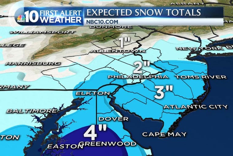
HOW MUCH?
The Wednesday afternoon computer models varied a bit: from nearly zero measurable snow (mostly melting) to a few inches. The best chance of the higher amounts looks to be Central and Southern Delaware and extreme South Jersey. Both areas are closer to the storm track. Here is our snowfall forecast:
THE THINGS TO WATCH FOR ("WILD CARDS")
A couple of things could add or subtract from the snow totals:
WOULD MEAN MORE SNOW
Storm tracks farther north.
Storm intensifies even more than expected.
Heavier snow before sunrise Friday than currently expected.
Temperatures a bit lower than predicted.
WOULD MEAN LESS SNOW
Farther south storm track (or weaker storm).
Snow light enough to melt even if it falls for hours.
Temperatures stay above freezing in snow areas.
Of course, stay tuned for updates on this storm, which could be the last one for a LONG time. Next week, temperatures should be going into the 70s.
WEEKLY FORECAST
Wednesday night: Clear and cold with diminishing wind. Lows of 26 in Philly, and 18 North and West.
Thursday: Sun to clouds. Cold. High of 39.
Friday: Slushy snow. High of 37.
Saturday: Clouds/cold. High of 44.
Sunday: Clouds to sun. High of 48.
Monday: Mostly sunny and warmer. High of 58.
Tuesday: Mostly sunny and warm. High of 66.
Wednesday: Mostly sunny and even warmer. High of 72.