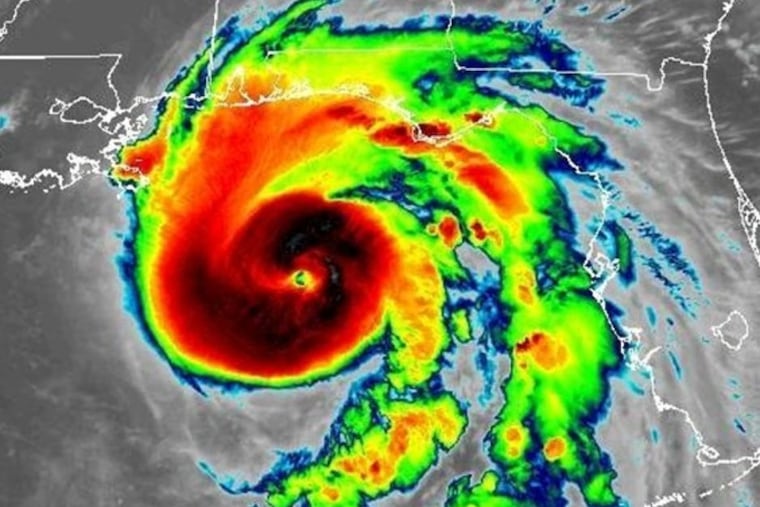
Hurricane Michael slams Florida panhandle in ‘worst case scenario’
Michael was nearly at Category 5 strength when it made landfall Wednesday afternoon. The storm's remnants could bring rain to the Philly region Thursday.

Hurricane Michael made landfall early Wednesday afternoon in the Florida panhandle with maximum sustained winds of 155 mph, just 2 mph short of Category 5 status.
The severe winds ripped roofs, sent debris flying through car windshields, and caused some structures to collapse. More devastation is expected to emerge in the area, which has never experienced a storm of this magnitude.
"We are in new territory," National Hurricane Center meteorologist Dennis Feltgen wrote in a Facebook post Wednesday morning. "The historical record, going back to 1851, finds no Category 4 hurricane ever hitting the Florida panhandle."
Michael strengthened in the hours before making landfall near Mexico Beach, Fla., with maximum sustained winds increasing from 145 mph to 155 mph. The National Hurricane Center warned of a life-threatening storm surge along parts parts of the Florida panhandle, with nine to 14 feet of inundation possible. Hurricane-force winds were also expected to reach as far as southeast Alabama and southwest Georgia.
Florida officials said more than 375,000 people up and down the Gulf Coast had been urged or ordered to evacuate, but authorities fear many people failed to heed their calls as the storm rapidly intensified over the Gulf of Mexico. Abnormally warm ocean waters — a feature that has become more common with climate change — helped energize Michael, which had been a Category 1 storm as recently as early Tuesday.
Unlike Hurricane Florence, which slowed after it made landfall last month and dumped more than 20 inches of rain in parts of the Carolinas, Michael is expected to move rapidly through parts of the southeast and Mid-Atlantic before churning out into the Atlantic Ocean.
>> READ MORE: For Philly firefighters, Florence floodwaters test their skills, patience, and families back home
Philadelphia is likely to see Michael's remnants Thursday afternoon, when the National Weather Service says two to three inches of rain could fall, with the heaviest amounts closer to the Shore. A flash flood watch has been issued.
The past two hurricane seasons have claimed numerous lives. Florence killed 50 people and caused tens of billions of dollars in property damage in September.
Last year, Hurricane Maria killed nearly 3,000 people in Puerto Rico, where the response by federal officials and President Trump was widely criticized. (This year, the president falsely tweeted that Democrats had manufactured the death toll to make him look bad). Hurricane Harvey also killed more than 80 people and caused catastrophic flooding in southeast Texas, where the storm slowed after making landfall.
Here is what happened with Hurricane Michael prior to and just after landfall Wednesday:
Images of damage begin to emerge
In Mexico Beach, where the storm made landfall, video showed a house that had been ripped apart.
In nearby Panama City Beach, severe wind damage was also reported. One image showed debris that had gone through a car windshield, while video showed debris and flood waters around a hotel parking lot.
A newly-constructed building was also seen collapsing.
Hurricane makes landfall at nearly Category 5 strength
Michael made landfall near Mexico Beach, Fla., early Wednesday afternoon with maximum sustained winds of 155 mph.
Powerful winds are pounding the panhandle.
Landfall ‘imminent’
The National Weather Service warned just before noon that landfall is imminent. "THIS IS A WORST CASE SCENARIO," the weather service tweeted.
Video from Panama City Beach, Fla., showed intense winds arriving.
Michael continues to strengthen just before landfall
The maximum sustained winds have increased from 145 to 150 mph as of late morning. The storm is expected to make landfall early this afternoon.
The National Weather Service in Tallahassee issued an "extreme wind warning" for the first time ever, saying winds in excess of 130 mph are expected in the coming hours.
‘This is an event that will have unprecedented impacts,’ National Weather Service says
The weather service's Tallahassee office is warning that a life-threatening storm surge and high winds "will result in widespread power outages that may last days to even more than a week in some areas."
Time for evacuations has ‘come and gone,’ Florida governor says
Gov. Rick Scott warned people who stayed behind that emergency responders won't be able to help them in the middle of the storm.
The Republican governor called it the worst storm that the Florida panhandle had seen in more than 100 years and said he was worried about people who stayed behind.
Indirect impact on Philly, but potential for tropical-style downpours
Michael will have indirect impacts on the Philadelphia region, with a potential for tropical-style downpours on Thursday and localized flooding. The National Weather Service will make a call Wednesday afternoon as to whether to post flood watches, said Patrick O'Hara, a meteorologist in the Mount Holly office.
"It's hard to believe someone won't be getting heavy rain," he said. The official forecast sees 1 to 2 inches of rain for the immediate Philadelphia area, starting in the early morning hours Thursday and continuing into the evening, and the government's Storm Prediction Center has the region under a "marginal risk" for severe weather.
As Michael's remnants track toward the southeast coast, a cold front approaching from the west will act as a railway to transport its moisture northward. The air around here already is swollen with water vapor: "It's like August humidity in October," O'Hara said.
The front ultimately will broom away the humidity, replacing it will a dramatically different, refreshing Canadian air mass. By Saturday morning, Philadelphia could experience its first readings in the 40s since May 1.
Storm surge already hitting parts of Florida coast
Hours before the storm was expected to make landfall, waters were already rising near the coast.
The Associated Press contributed to this story.