What’s planned for 30 acres of Manayunk’s Venice Island? Residents worry.
Still reeling from Hurricane Ida’s damage, locals fear a development could worsen future flooding and trap residents on the island.
Geoff Woolery was landscaping outside his townhouse on Manayunk’s Venice Island last summer when scores of dump trucks began trundling by.
He watched the hours-long parade, increasingly curious as the trucks entered the long dormant property at 5000 Flat Rock Rd., off the northwestern tip of the island.
“There must have been at least 50 trucks,” Woolery said. “It was just absolutely nonstop.”
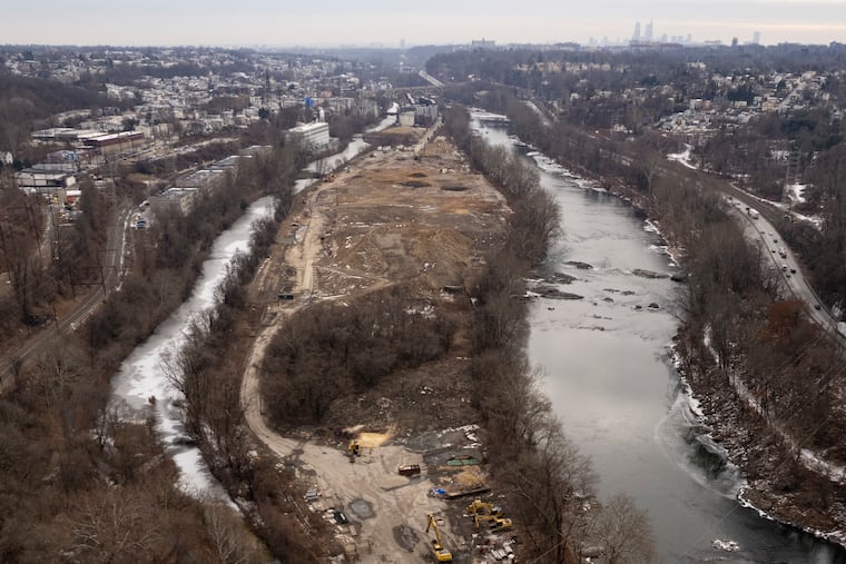
Trucks and other heavy equipment have continued to comb the property at 5000 Flat Rock Rd., hauling in and piling hills of soil on the 30-acre property once slated for development by former Dallas Cowboys star Emmitt Smith.
But neither Woolery nor any of his neighbors — not even the local City Council member — understand why. No building plans have been submitted for the property, which composes about 45% of the island’s land mass.
Manayunk residents and community groups worry that a major development looms for the largest open parcel on the island — and a rare big undeveloped space in the city. Still reeling from flooding by the remnants of Hurricane Ida in 2021, they fear a development could worsen future flooding and trap residents on the island.
“Ida was the most devastating flood,” Woolery said. “But it’s been one flood after another.”
After Smith’s 2018 plan to build a sprawling campus of labs, offices, and homes on the island never materialized, Manayunk Renaissance LLC, a subsidiary of A.P. Construction, purchased the property in 2021 for $23 million. The construction company razed a shuttered paper mill on the property and later began hauling in fill and grading the land.
As of this month, fill has been piled or spread to raise the height of the property above the river and canal on the Flat Rock Road site.
“We don’t know what’s going on and you can’t get any questions answered,” Woolery said.
More homes for Venice Island?
A.P. Construction is a South Jersey-based construction company, with an office at the Navy Yard. It boasts a portfolio of big projects in the region, including work on bridges, stadiums, and the Manayunk Bridge Connector Trail and Park.
Its 5000 Flat Rock Rd. property lies within a floodplain and is zoned industrial. Currently, the Philadelphia Water Department (PWD) is finishing work on the Flat Rock Dam, just above A.P. Construction’s property. PWD’s project is designed to reconnect the Manayunk Canal with the Schuylkill, better manage stormwater, and improve local water quality.
“I think it’s inevitable that they’re going to be proposing a large residential development there,” said Kevin Smith, president of the Manayunk Neighborhood Council. “The site has massive, if not insolvable, egress and flood safety issues. It’s amazing that nothing is known about such a large project. That seems hard to believe, right?”
A.P. Construction did not respond to requests by The Inquirer for its plans.
The company has permits to grade and raise the property but has not submitted development plans. It’s also possible A.P. Construction could be preparing the land to sell. The company also owns a smaller adjacent property with a site work permit to grade and raise a portion of that 2.5-acre lot above the floodplain.
The land is in Councilmember Curtis Jones Jr.’s district. Jones said he does not know the company’s goal.
“The only thing they’ve talked about specifically is to get it above floodplain … high enough to withstand a flood,” Jones said, noting that “100-year storms seem to happen every three years now.”
The Council member said the company has not given his office “any direction” on the site.
What’s Venice Island?
Venice Island, one of the lowest lying areas of the city, is a narrow wedge of land, just shy of 70 acres and roughly 1.7 miles long between the Schuylkill and Manayunk Canal.
It was created between 1817 and 1823, when the canal was dredged. A base for the textile industry, it drew thousands of European immigrants, who settled in Manayunk’s muscular hills to work in 16 mills that once lined the island.
As the mills shuttered because of changing economic forces, Manayunk took an economic downturn.
The neighborhood began to boom again in the late 1980s, and Main Street emerged as a nightlife center. Manayunk was back and desirable.
In 1999, former Mayor Michael Nutter, then a City Council member, worked to rezone Venice Island from industrial to residential as demand for housing grew. That same year remnants of Hurricane Floyd dumped 10 inches of rain, the Schuylkill rose to 14.1 feet, and parts of the island were submerged. But city officials pressed on, and in 2000, the Zoning Board of Adjustment granted the first variances for two housing developments.
The Manayunk Neighborhood Council sued to block the developments by Carl Dranoff and Dennis Maloomian. In 2001, a Common Pleas Court judge agreed with them that an apartment development “poses too great a risk to human life and property.” A Commonwealth Court overturned that judge’s decision, and the state Supreme Court refused to take up the case, allowing construction to proceed.
High-risk flood zone
Venice Island lies within a high-risk, 100-year-floodplain designated by the Federal Emergency Management Agency (FEMA), meaning it has a 1% chance of flooding in any given year.
All of the island was listed as being in a floodway, which is the most dangerous part of a floodplain, meaning it is susceptible to fast-moving water during a flood.
However, developers later persuaded FEMA to designate some of the island out of the floodway, which paved the way for homes to be built.
Today, Venice Island contains at least 260 housing units across multiple projects, including the Apex Manayunk apartments, formerly Dranoff’s Venice Lofts.
When Hurricane Ida deluged the region in September 2021, the Schuylkill overflowed and flooded Main Street in Manayunk, swamped the island, and forced residents from waterlogged apartments such as Apex to cross the bridge to safety as waters rose below.
The thought of another storm like Ida terrifies residents.
‘Frustrating disconnect’
A.P. Construction applied for a city permit in 2022 to demolish the old paper mill.
It subsequently applied for permits to truck in enough fill to raise most of the site above the floodplain. An engineering plan submitted by Pennoni Associates for the permit gave no hint of future plans, only noting that “the current use of the site is vacant which will not change.”
Concerned residents say the work has been obscured from view of casual observers because it lies north of Leverington Avenue and bustling Main Street. Heavy equipment crawling the site can be viewed from a wooded path along the canal.
Opponents of building more homes along the canal and river say FEMA maps are outdated and don’t reflect even more risk of flooding due to climate change. Sewer outfalls along the Schuylkill can back up during a storm, adding to flooding.
Concerns are serious enough that Manayunk and East Falls development corporations joined forces to issue a study on flooding preparedness last year.
Regardless, developers have gobbled up former industrial sites and are applying for zoning variances to build housing.
“What I consistently find as a challenge is people’s lack of understanding about the power of water,” said Kay Sykora, a 30-year resident of Manayunk who has helped trapped motorists during storms. “There is a disconnect that’s really frustrating at times.”
John Hunter, an architect and zoning chair of the Manayunk Neighborhood Council, has argued at zoning meetings against more waterfront housing.
Seven storms have flooded Main Street since 2010, he said, two of which were major floods that included a 2014 storm and Ida in 2021, which infamously trapped residents on the island.
Most recently, however, the city’s Zoning Board of Adjustment, with Jones’ support, granted variances in December for a residential development at 3900 Main St., south of the island. The Manayunk Neighborhood Council argued against approval.
Hunter said it’s “almost inevitable” that A.P. Construction will need Jones’ support if it proposes a development.
“The project would be so big that it will not need just a variance, but a bill through the city sponsored by Councilmember Jones, so he is becoming pivotal in these developments,” Hunter said.
John Carpenter, a resident for four decades and a board member of the Roxborough Manayunk Conservancy, also fears the widely used Manayunk Canal Towpath, a section of the Schuylkill River Trail, could also see more flooding with additional development.
“The towpath trail was severely damaged during Ida,” Carpenter said. “Increased displacement of water coming off all this fill is likely to make damage to that towpath trail even more frequent and more severe. And yet, it’s a primary gateway for cyclists and runners.”
One way out
Venice Island is separated from the mainland by three, two-lane bridges and a single one-lane bridge.
Josh Lippert, the city’s former floodplain manager, calls potential residential development “concerning,” given there would be only one city-owned bridge to serve the area now being graded and prepared by A.P. Construction.
“What’s the risk to first responders in a flood? Lippert asked. “The site is very inaccessible. Even during a non-flood event there’s only one way in and one way out.”
He said climate change and increased development upstream only serve to make the impact of flooding more precarious.
“Buildings are built for today,” Lippert said. “They’re not built for the future.”