Are abnormal tornado activity, other extreme weather a sign of climate change?
“It has certainly been an above normal year for severe weather with tornadoes,” said Alex Staarmann, a meteorologist with the National Weather Service office in Mount Holly.
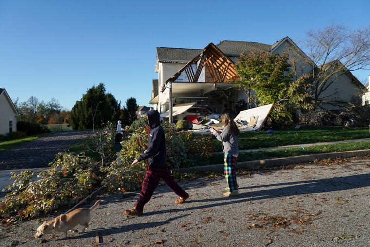
A tornado that struck Delaware County late on Halloween evening added to an already unusual year in Pennsylvania and New Jersey for cyclonic activity.
“It has certainly been an above-normal year for severe weather with tornadoes,” said Alex Staarmann, a meteorologist with the National Weather Service office in Mount Holly. “I do know that New Jersey has had eight this year and the average is two.”
Staarmann said Pennsylvania’s average is 16. The state had likely surpassed that prior to the confirmed tornado that touched down in Thornbury Township on Thursday evening, though Staarmann did not have an official statewide count.
The weather service’s survey team confirmed that it was an EF2 tornado, which is classified as having damaging wind speeds of 111 to 135 mph. Such powerful winds can not only down trees, they can shift homes off foundations, tear off roofs, and even lift cars.
Indeed, the tornado in Delaware County ravaged eight homes, displacing 20 people, and dozens more residents had damage such as broken windows, and missing siding and shingles.
Staarmann said late October tornadoes are not unheard of, but are not common. Peak tornado season is mid-July.
Though it’s difficult to tie a single weather event to climate change, an increase in extreme weather fits in with scientists’ explanation of the impact of an overall warming of the planet and oceans, as more heat and more moisture create more energy to feed storms.
Yesterday’s extreme weather was powered by a strong cold front colliding with unusually warm October temperatures. At 11 p.m. Thursday, the temperature reached 73 degrees, 12 degrees above normal. By 1 a.m. Friday, the temperature had dropped to 55 degrees.
“And that’s one of the ingredients that leads to strong, severe thunderstorms,” Staarmann said of a rapid rate of change in the atmosphere, resulting in conditions that produced what’s known as wind shear, which can lead to a tornado.
Under such conditions, wind speeds several kilometers above the Earth are much faster than at ground level, causing rotation.
The Halloween night tornado isn’t been the only unusual recent weather in the Philadelphia region.
Overall, temperatures in Philadelphia averaged 61.2 degrees Fahrenheit for the month, or 3.87 degrees above average, most notably reaching 97 degrees in Northeast Philly on Oct. 2.
It marked the 10th-straight October of above-normal temperatures in Philadelphia.
September was also warm, averaging 72.5 degrees Fahrenheit, or 3.4 degrees above normal.
And though 2019 started out rainy, it dried out by late summer and into the start of September. Precipitation is now running about normal.
However, the decade so far has been the wettest ever in terms of 10-year rainfall averages at Philadelphia International Airport. Additionally, the average rainfall for the 21st century through 2018 (49.4 inches) is more than 8 inches higher than the 20th-century average.
More than a half inch of rain fell in Philadelphia Thursday, pushing the total for October close to 3.7 inches — triple what fell in a parched September.
Steve Decker, a Rutgers meteorologist, said this year has been "above normal for tornadoes in the Northeast for sure.”
Decker said that scientists aren’t sure if that is because of man-made climate change, or if it’s a natural phenomenon.
“I don’t think anyone has figured out the answer,” Decker said.
However, Decker did note that, at least in New Jersey, it has been warmer — one of the ingredients in a complex stew of factors that could contribute to more cyclonic activity.
He said this year has seen not only warmer weather, but more wind activity aloft, meaning 3 to 6 kilometers above the ground, another factor in creating optimal conditions for tornadoes.