Adam Levine, the sewer expert, tracks Philly’s hidden streams
Hundreds of miles of streams were hijacked in the 19th and 20th centuries to provide infrastructure for the city's sewer system.
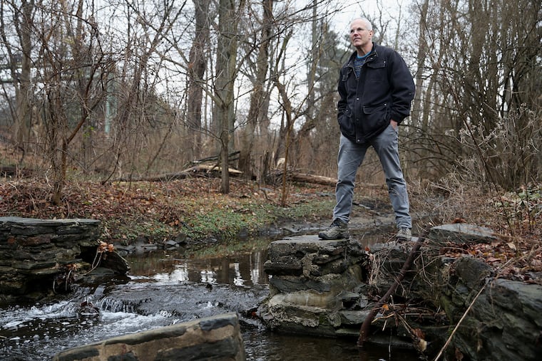
On a recent morning, Adam Levine, historical consultant to the Philadelphia Water Department, drives along Valley Road in Merion, pointing out a small, scenic stream.
Mill Creek courses through the front yards of the stately homes here, contained by stone walls that rise up from the creek bed. Some houses have wooden footbridges that cross over the gap; others have flagstone patios perched on the banks.
The stream starts half a mile north of the Merion stop on SEPTA’s Regional Rail line, bubbling out of a spring by a cul-de-sac. It flows south along the Paoli-Thorndale tracks, toward Overbrook. Follow past that and it curls southeast, through its namesake neighborhood in West Philly, until it meets the Schuylkill.
Except you can’t follow Mill Creek much further without Levine’s help. Just by Overbrook station, it flows into the mouth of a large pipe and becomes a sewer. From there, it runs underground. Starting in 1869, it was hijacked to serve as an artery for the city’s growing sewer system.
Mill Creek is one example of what happened to hundreds of miles of streams in Philadelphia (and across the country) in the late 19th and early 20th centuries. They were conscripted into service of the city’s 3,000-mile drainage system. Sometimes, streambeds’ natural valleys provided a cradle for pipes; other times, they were rerouted. That complicated environmental-meets-developmental history is the subject of Levine’s illustrated lecture at the Wagner Free Institute of Science on Feb. 20.
“Little streams in developed areas have never been really respected,” Levine says. Even the parts of Mill Creek that remain above ground were carefully shaped by Merion’s designers.
“Normal streams don’t have stone walls and they don’t flow on concrete. They don’t flow into sewer pipes and disappear.”
He steers out of the 1920s-era development and heads down Merion Road toward the city line, past the Merion Botanical Park, which the creek passes through unobstructed. “Can you guess why it was called Overbrook?” he asks dryly as he waits for the light at City Avenue.
Levine gets out of the car at the Regional Rail station and walks up the platform’s ramp. Mill Creek runs just to the right, then vanishes into the arch of a large pipe, tastefully embedded into the hillside with old stone walls. On a snowy morning, under a frosted-glass sky, you could be forgiven for thinking this passes for pretty. A faint cloud of water vapor floats up from where the freshwater stream flows into the pipe. “Because sewage is warm,” Levine notes.
From here, Mill Creek — now the sewer — runs underground, gathering wastewater and stormwater from the homes and businesses hooked up to its pipeline, carrying it toward a treatment facility. (That wasn’t always the case: A boy fell into the stream around Overbrook in 1969 and washed all the way to the Schuylkill. He lived.) Before it was buried, it was fed by other tributaries, also appropriated for infrastructure and covered up.
But just because it isn’t visible doesn’t mean Levine can’t follow it. For 20-plus years, he’s managed the Water Department’s extensive archives. He has pored over city maps for much longer than that. And as the editor of the Pennsylvania Horticultural Society’s magazine and the author of two Philadelphia gardening books, he claims a far better-than-average knowledge of nature and history. Often, all it takes for him to track a stream-based sewer system is to look at the streets.
“When you’re in the city and you think you’re in a valley, you probably are in a little creek valley, even if there’s no creek there,” he says as he straps himself back into the car.
Maybe you’ve never thought, “I’m in a valley.” Pay attention to the slopes of the streets, especially if they’re winding, Levine says. He drives on Upland Way toward Lebanon Avenue, patiently noting the road’s topography along the way. It’s even easier to notice if you’re on a bicycle.
After pipe was laid, the valleys would be leveled with fill. Land wasn’t smoothed out completely, just enough to build on, Levine says as he navigates south on 59th Street, over Lancaster Avenue. He begins working his way east, toward the Mill Creek neighborhood.
For the most part, streets were built on the land above sewers. That was not the case for all parts of the Mill Creek sewer, especially for a five-block area near 51st and Brown Streets. In 1961, four rowhouses on Funston Street collapsed there, burying seven people and killing three.
When he nears the area, Levine circles around a series of empty lots, “a swath of nothing,” he says. The city bought the land from property owners after the incident. He recalls a set of keys he found in the Water Department archives that he couldn’t identify for a long time. He eventually figured it out. “It was the keys to all the houses on this diagonal that were over the sewer that had to be torn down.”
By the 1920s, the city realized it was more expedient to leave streams as they were. That’s why Northeast Philadelphia, which was developed later, has more tributaries — Byberry Creek, Wooden Bridge Run, Axe Factory Run — that flow above ground. “From the time of buying up the land, then building the pipe, burying the stream, filling it, and then the neighborhood being built around it — it would sometimes take decades.”
Driving around with Levine can feel like falling down a Philly rabbit hole. As he tracks Mill Creek’s path to its end, at 43rd Street, he takes conversational diversions: the desire of early-20th-century city planners to create more diagonals in Philly’s grid; the fate of the Institute of Pennsylvania Hospital men’s and women’s facilities; the claustrophobia one can develop when walking in a sewer (a story for another time).
As he passes by rowhouses, bodegas, cafes, and salons, he summons a pastoral image of old West Philly: mostly farmland, some woods, unfettered streams. Once industry came to the area, it used the water for power or, in the case of textile factories, for bleaching and dyeing. “And they would of course dump the polluted water right back in the creek.”
Even then, little streams didn’t get respect.
From Stream to Sewer: A History of Philadelphia’s Landscape, 6 to 7:30 p.m. Wednesday, Wagner Free Institute of Science, 1700 W. Montgomery Ave., free with registration, 215-763-6529, wagnerfreeinstitute.org