More Debby-related downpours are likely, with ‘favorable conditions’ for tornadoes Friday, forecasters say
The center of Debby’s remnants is forecast to pass west of the region Friday, generating strong winds.
By the time its remnants get anywhere near the Philly region, Debby will have become a mere blob of moisture with a name.
But the next two days may be quite eventful in the Philly region as the atmosphere takes on more tropical characteristics and becomes more volatile, forecasters are warning.
As the remnants of Tropical Storm Debbie make a northward push, passing west of Philadelphia on Friday, its rapidly moving rain bands could set off flash-flooding late Thursday afternoon, the National Weather Service says.
In addition, with the region east of the center on Friday, “favorable conditions” may be in place for tornado development, according to the weather service. And winds at the Shore could gust to 55 mph, said Dave Dombek, senior meteorologist with AccuWeather Inc..
With the expected track of the storm having jogged westward, projected rainfall amounts have been trimmed back a few splashes. A total of 1 to 2 inches are expected in the immediate Philly region, with slightly less to the east. That said, any downpours could bump up the totals, forecasters say.
Debby-related rains have been causing issues around since Tuesday, softening the ground, making trees vulnerable and the winds all the more dangerous, Dombek said.
After several hours of flooding rains Tuesday night into Wednesday that led to scores of water rescues, it appears that the region is in for additional Debby-related soakings through Saturday, with a swelling flooding potential.
“Depending on how much we get, we may have additional flooding issues into the weekend,” said Mike Lee, a meteorologist at the National Weather Service in Mount Holly.
The bulk of the additional rain is due Thursday night through Friday night with the approach of Debby’s leftovers. Even the center st to pass well west of the region. “You definitely see impacts away from the center,” Lee said.
The forecast remains somewhat of a moving target, given that on Thursday Debby was inland of South Carolina, according to the National Hurricane Center.
» READ MORE: Live tracker: How Tropical Storm Debby could impact the Philly area
The Carolinas were confronting a “major flood threat,” the hurricane center said, and the Pennsylvania Emergency Management Agency dispatched 45 task force members to Raleigh to help with the aftermath.
The Philly rains have been the result of moisture plumes streaming north from Debby, interacting with a front draped just to the south of the region. “Whatever the cause, rain is rain,” said Dave Dombek, senior meteorologist with AccuWeather Inc.
“Raindrops don’t have letters in them,” he said, no “D” for Debby or “f” for front.
Debby’s rains so far
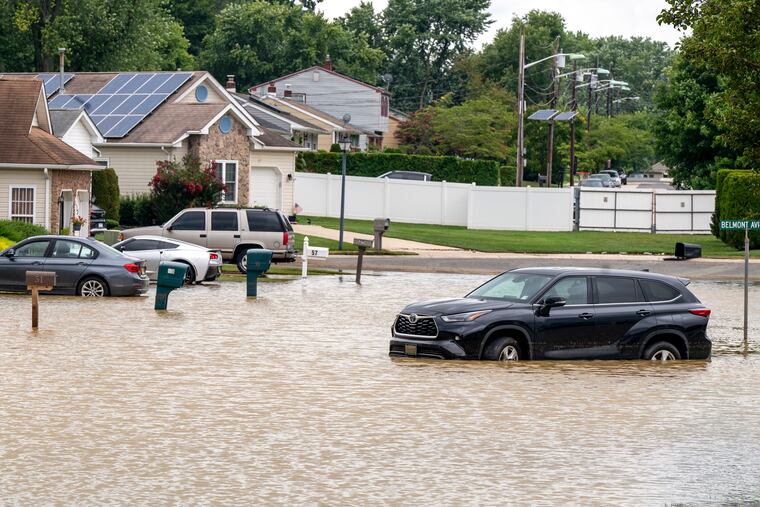
Parts of Burlington County were inundated. While no injuries were reported, first responders executed more than 75 rescues involving vehicles trapped in flood waters, said county spokesperson David Levinsky. Portions of Route 130 remained closed Wednesday.
Just over six inches was measured in the Delran area, and amounts of three and four inches were common elsewhere in Burlington County and in Bucks and Camden Counties on Tuesday night into early Wednesday, the weather service said.
The areas particularly hard hit were slices of those counties along the Delaware River, including sections of Bensalem and Bristol Township in Bucks County, said Lee.
» READ MORE: How much Debby-related rain fell near you
Numerous other incidents of road flooding and water rescues were reported, and rain may have resulted in a roof collapse in Bristol Township, the weather service said.
Both PATCO and SEPTA reported service disruptions, and Philadelphia International Airport is experiencing yet another day of significant delays and cancellations related to Debby. On Wednesday, 31 flight cancellations and 72 delays were reported, said spokesperson Heather Redfern.
Why hasn’t the flooding been worse?
For the last two months the entire region has been running rain deficits, and river and stream levels generally were low before the rain started.
Levels spiked upward on some of the smaller, flashier waterways, said Lee, but the bulk of flooding was confined to roadways.
The flooding potential the rest of the week
Although the Debby-related storm totals may rival the amounts that typically fall over a two-month period, the rains will continue to come in shifts, forecasters say.
Neither of the main-stem rivers, the Delaware or the Schuylkill, is expected to approach flood stage.
However, that could change, depending on where and how quickly additional rain falls. Plus, it typically takes the rivers a day or two to respond to upstream downpours.
Showers and thunderstorms are possible Wednesday and Wednesday night, the weather service says, with heavier amounts likely Thursday through Friday night.
For now, the flood watch advisories have been taken down, but they are quite likely to return during the next two days.
On a positive note, the approach of Debby’s leftovers may restore some order to the surf at the Shore, which has become a version of San Francisco east with dense fog advisories in effect until 4 p.m. Wednesday.
Water temperatures off Atlantic City remained in the 50s Wednesday, where they have been much of the first week of August. That’s the result of “upwelling,” in which steady winds from the south have blown away the warmer upper levels of the water. Interacting with the sultry overlying air, the chilly waters are brewing a fog bank by the sea.
As it gets closer, the storm is forecast to generate onshore winds from the east that should import the warmer water and bump up surf temperatures to near normal levels, in the low 70s.
And after all those steamy days, no new heat advisories are in sight. If Thursday’s forecast holds, it will be the first day since June 11 that the temperature failed to reach 80 degrees.
The weekend forecast is about as good as it gets in August with back-to-back sunny days and comfortable temperatures in the low to mid-80s, with the humidity gradually retreating.
Staff writer Beatrice Forman contributed to this article.