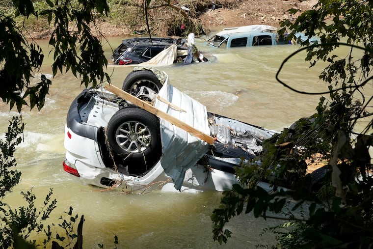
Henri saturates New Jersey, but with rain totals far lower than tragic deluges in Tennessee
At least 22 were killed in Tennessee. More than seven inches of rain fell on Long Beach Island, with nine-plus elsewhere in New Jersey.
After saturating portions of New Jersey, upstate Pennsylvania, and the New York area, Henri finally was downgraded to a tropical depression Monday afternoon.
But for all its celebrity and associated mayhem, by the time Henri’s downpours reached the Northeast during the weekend, the tropical system already had been upstaged by a rainstorm without a name in Tennessee.
Tennessee’s death toll Monday stood at 22 and might go higher, and the 17.02 inches of rain measured in the small, west-central town of McEwen on Saturday would be a Tennessee record, said Krissy Hurley, the warning-coordination meteorologist for the National Weather Service Office in Nashville.
“It is legit,” said Hurley, adding that the measurement was taken at a rain gauge owned by the Tennessee Valley Authority.
The immediate Philadelphia area, meanwhile, experienced a rather ordinary 1 to 2 inches, and despite sequences of downpours in recent weeks, for a variety of reasons the region has evaded catastrophic, widespread riverine flooding — and is likely to continue to do so.
» READ MORE: Fred remnants set off floods in the Philly region, two tornadoes, and whole lot of phone alarms
The situation was dangerously different in parts of New Jersey where Henri-related rains were impressive: Close to 5 inches was reported on Long Beach Island and nearly 9 elsewhere in the state. A flood warning was in effect along the Raritan River in northern New Jersey.
But what occurred in Tennessee exceeded anything wrung out from Henri or its remnants.
Trouble in the air
In the 73 years that the weather service has been launching weather balloons, it had measured nothing like what was in the skies over Tennessee on Saturday morning.
“The amount of moisture in the atmosphere was record-setting for the date,” Hurley said. The trigger for squeezing out the water was an upper-level system. Henri, whose center passed off the coast a good 750 miles from McEwen, was guilty only by association.
The Nashville office rather boldly on Friday warned that up to 9 inches of rain could fall in the area. That turned out to be conservative. That TVA gauge measured 9 inches in three hours — 3 inches in three consecutive hours.
“In my 20-year career this is the most rainfall I have seen outside of any type of tropical system,” she said.
Evidently the deadly flash floods occurred when water from Trace Creek sloshed westward, and downhill, after 10 to 14 inches of rain had fallen, she said.
» READ MORE: The heat from Center City’s buildings and streets might be giving the rains a little extra juice
Absent winds to move them along, the rains kept punishing the same places. “It was a series of training thunderstorms along a stationary front,” said Jordan McLeod, a climatologist at the Southeast Regional Climate Center
Hurley said the weather service would be working with the climate center to verify the record.
Henri’s career
Henri generally followed the predicted tracks, making a hard right offshore of the Georgia-South Carolina coast then moving north.
It grew into a Category One hurricane, with peak winds just over the 74-mph threshold for hurricane status, passed within 200 miles of the New Jersey coast, and made landfall on Rhode Island with top winds of 65 mph, then jogged westward.
Henri did wring out prodigious rains along the way, with more than 7 inches on Long Beach Island, nearly 9.5 inches in Cranbury, Middlesex County, N.J., more than 7 inches in Long Beach Township, 10 inches in Brooklyn, and 5 inches farther north in New England.
Philly’s luck
Philadelphia had its second encounter with tropical storm moisture in just a few days, yet somehow the city itself split the uprights in terms of deluge dodging.
On Wednesday, the core of the remnants of Tropical Storm Fred passed about 300 miles west of the city, and while areas to the north and west, including the Main Line, experienced a month’s-plus worth of rain, parts of the city didn’t see much at all, and the official station at Philadelphia International Airport saw basically nothing.
» READ MORE: Despite a recent lull, the Atlantic hurricane season is about to experience a serious second wind
The center of what was then Hurricane Henri was about 225 miles east of the city when it reached Philly’s latitude. In tandem with that upper-level system, amounts in the city ranged from 1 to 2 inches.
Fortunately for the region, the heaviest rains haven’t been targeting the same places. Plus, the August foliage is so lush that it has been drinking a lot of that water, said Tom Kines, senior meteorologist with AccuWeather Inc.
“The grass is going to grow 2 feet,” he said.
For now, the weather service’s long-range outlook has a minimal risk for riverine flooding.
In the short term, the region remains situated in a humidity factory, with a sultry air mass and that lush vegetation feeding it more moisture.
Incredibly, for the first time in at least a week, no showers are in the forecast Tuesday and Wednesday. It will just be hot and uncomfortable, with temperatures in the 90s.
Showers return to the outlooks later in the week, and that persistent shirt-soaking mugginess isn’t going anywhere. “There’s no relief anytime soon,” said Kines.
And three more potential tropical storms are brewing in the Atlantic.