Philly forecast: No additional storms, but it will 'feel like winter' the next few days
Snow is likely to continue for a few more hours Tuesday morning, but the bulk of the accumulating snow appears to be over, and this may be as much as the region sees for awhile.
Some light snow or rain is possible Thursday night and early Saturday, but for accumulation, this one was the “big enchilada” for the foreseeable future, said Dave Dombek, senior meteorologist with AccuWeather Inc.
Not that Philly and some other places got all that much to eat.
Gift this article!
Link copied to clipboard
Link copied
What went right and wrong with the snow forecast
Parts of the Philadelphia region have just experienced what was by far their biggest snowfall this winter, even if the vast majority of people living in the city and areas to the south and east might find that rather unimaginable.
Some towns in Bucks, Chester, and Montgomery Counties weighed in with 7 to 9 inches on Tuesday, and others with 3 to 6 inches of ultra-heavy, picturesque snow that pasted itself onto trees. A whole bunch of that white mass came in a hurry during what ordinarily would be the peak morning commuting hours.
“It wasn’t a huge powerhouse of a storm,” said Dave Dombek, senior meteorologist with AccuWeather Inc. “It’s doing it’s thing, and it’s getting out of here.”
Gift this article!
Link copied to clipboard
Link copied
Speed limits restored on several Philly-area highways
The speed limit on several highways across the region have been restored to normal after being reduced to 45 mph during Tuesday morning's winter storm.
PennDOT says it is continuing to treat roadways and advises drivers to keep their distance from plow trucks.
– Rob Tornoe
Advertisement
Gift this article!
Link copied to clipboard
Link copied
How much snow has fallen in the Philly region?
Snow reports are still coming in, but here are a few preliminary totals from around the region, and, as expected, the vary widely.
The next official measurement at Philadelphia International Airport will be taken at 1 p.m.
Bucks County
East Telford: 8.9
Gift this article!
Link copied to clipboard
Link copied
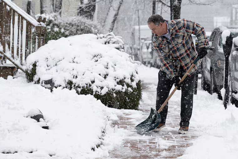
Photos: Snow falls across the Philly region
Advertisement
Gift this article!
Link copied to clipboard
Link copied
Up to 8 inches of snow in Montco, not so much elsewhere
It will be awhile before the totals are tallied, but as expected, they are going to vary wildly.
Just over 8 inches was measured by a trained observer in Upper Hanover Township, Montgomery County, the National Weather Service reported, and 3- and 4-inch amounts were common in Philly’s neighboring Pennsylvania counties.
However, from the city on south and east, the totals are likely to finish in the inch range, if that in some places.
Gift this article!
Link copied to clipboard
Link copied
Snow should shut off mid-morning, forecasters say
In a quick burst Tuesday morning, 2 to 3 inches of heavy, wet snow have accumulated north and west of Philly, and a heavy band was heading toward the city, said Robert Deal, a lead meteorologist at the National Weather Service Office in Mount Holly.
He added that the snow likely will have shut off across the region by 10 a.m.
Winds are forecast to pick up later, with gusts of 35 mph possible.
Advertisement
Gift this article!
Link copied to clipboard
Link copied
Dozens of flights delayed or canceled in Philly
Tuesday's winter storm is wreaking havoc in travelers passing through Philadelphia International Airport.
At least 30 flights in Philadelphia have been canceled Tuesday, according to FlightAware, while at least 65 more have been delayed. Departures were running on a 45-minute delay Tuesday morning.
The airport encourages passengers to check with their airline for updates.
Gift this article!
Link copied to clipboard
Link copied
Photos: Snow falling in Philadelphia
Advertisement
Gift this article!
Link copied to clipboard
Link copied
Several SEPTA trainings running late due to the snow
Gift this article!
Link copied to clipboard
Link copied
Handful of Montco towns declare snow emergencies
A handful of Montgomery County towns have declared snow emergencies ahead of Tuesday’s winter storm.
Both Hatfield Township and Hatfield Borough are under snow emergencies for the duration of the storm, Hatfield police announced. Officials are urging residents to keep all non-essential vehicles off roadways.
Lower Salford Township has also declared a snow emergency until 7 p.m., the town’s police department announced. Lansdale Borough is under a snow alert “until further notice.”
Gift this article!
Link copied to clipboard
Link copied
Rain rapidly shifting to sleet and snow
Rain is rapidly shifting to sleet and snow across the Philadelphia region.
The snow will become heavy at times during rush hour Tuesday morning, according to the National Weather Service, so conditions on roadways could be dangerous at times.
One to 2 inches of snow an hour during the storm's most intense moments are possible, forecasters said.
Gift this article!
Link copied to clipboard
Link copied
Schools in the region are closed or delayed, including the School District of Philadelphia
Many schools in the Philadelphia region are closed or on a modified schedule as rain turns to snow and the commute becomes messy.
With an eye toward Tuesday’s winter weather advisory, all Philadelphia School District schools and its central office will operate on a two-hour delay.
District officials warned parents that transportation delays were possible. But, they said, athletic events and after-school activities are still on, with no delays.
Gift this article!
Link copied to clipboard
Link copied
Rain to snow: It's that time of year
Accumulating snow that changes to rain is a staple of the Philadelphia winter.
Rain changing to accumulating snow is a less-common occurrence around here. But this is the time of winter when it’s most likely to happen, meteorologists say.
Most of our snow is generated by coastal storms that can import warm air from the ocean. Oceans take their good, old time cooling off and don’t reach their lowest temperatures until late winter, chilling the overlying air.
Gift this article!
Link copied to clipboard
Link copied
‘Heavy snow:’ Sometimes that’s literally true
Plow contractors charge by inches of snow. Yet not all inches are created equal, as anyone who has ever shoveled snow is aware.
Six inches of snow can be feather-light or feel more like 12 inches, depending on the water content of the flakes.
On average in this area, about a foot of snow pops out of every inch of precipitation, yielding a snow-to-liquid ratio of 12:1. When the atmosphere is especially cold, that ratio can jump to 20:1 or higher.
Gift this article!
Link copied to clipboard
Link copied
Heavy snow and gusty winds are expected for the morning commute Tuesday in the Philly region
A possibly disruptive period of heavy snow, with wind gusts to 30 mph, is expected during the Tuesday morning commute, forecasters say, with several inches possible north and west of the city.
Computer model runs on Monday were foreseeing a storm akin to a meteorological fireball exploding off the Mid-Atlantic coast during the morning, throwing back snow in defiance of the recent warm spell. Temperatures hit 50 degrees for the fifth consecutive day in Philly on Monday.
Snow accumulations could vary from nothing south and east of the city to several inches in Philly’s neighboring counties, and about the only certainty was that the totals were going to vary radically depending on temperatures and elevations.