Mammatus clouds, a rarity over Philly, put on quite a show Sunday
The clouds stole the thunder of the strong storms that preceded them.
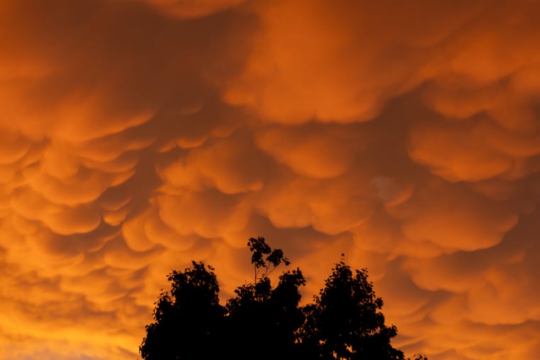
Those waterfall-like downpours and potent gusts Sunday were dramatic, but the mammatus clouds that turned the skies into a Van Gogh canvas and helped create a mystical orange-reddish glow stole the storms’ thunder.
The clouds that followed the storms appeared to get far more attention than all the rain and winds and warnings and advisories the National Weather Service had issued, said Sarah Johnson, the warning coordination meteorologist with the National Weather Service in Mount Holly.
“We got a lot of pictures on our social-media channel last night,” she said Monday.
Mammatus clouds, formed from sagging pouches of water vapor, are quite common in the Plains, but rare in the East, Johnson said.
As for that twilight glow, that was the result of a fortuitous set of circumstances.
What are mammatus clouds?
Mammatus essentially are backward-forming clouds that appear in the aftermath of thunderstorms.
Clouds develop when water vapor ascends and condenses into weightless droplets, but mammatus are anomalies, said Johnson.
They form from downward-moving air and are the vestiges of departed thunderstorms, such as the ones Sunday that featured end-of-the-world skies and cloudbursts, took down trees, and set off flooding in some areas. Nearly seven inches of rain was measured in Cape May County, and a gust past 60 mph was recorded in Camden, the weather service said.
That downward motion creates the sagging effect, almost as though the clouds are being inflated from above, Johnson said. “You see them bubbling up.”
As the Latin root suggests, the name does have a mammary connotation, said Harry Augensen, director of the Widener University Observatory.
Mammatus always follow episodes of strong thunderstorms, which create the environments for their creation. As so often happens, the very best of nature follows the worst.
What caused that afterglow?
As the clouds continued to peel away, they were electrified by a waning sun that splashed them with a vivid array of literal water colors that cast a glow through the atmosphere.
“We just had the perfect timing for the storms moving out right around the time the sun was getting close to setting,” Johnson said.
That created “perfect conditions to really showcase the mammatus and also give an interesting hue to the atmosphere,” she said.
Mammatus are commonplace in other parts of the nation
Mammatus are frequent visitors in other parts of the country, said Johnson, where conditions are more often conducive to their formation.
She recalled that when she worked in Texas about 15 years ago, mammatus were spotted over New York City and became a national sensation.
She said Texans were nonplussed by the hubbub, asking, “Why the heck would mammatus make national news?”
They appeared over New York. Why else?
Staff writer Milan Varia contributed to this article.