Not only will it remain stiflingly hot, but also ‘abnormally dry’ with little relief in sight
Since April, Philadelphia has received only two-thirds of the amount of normal rainfall.
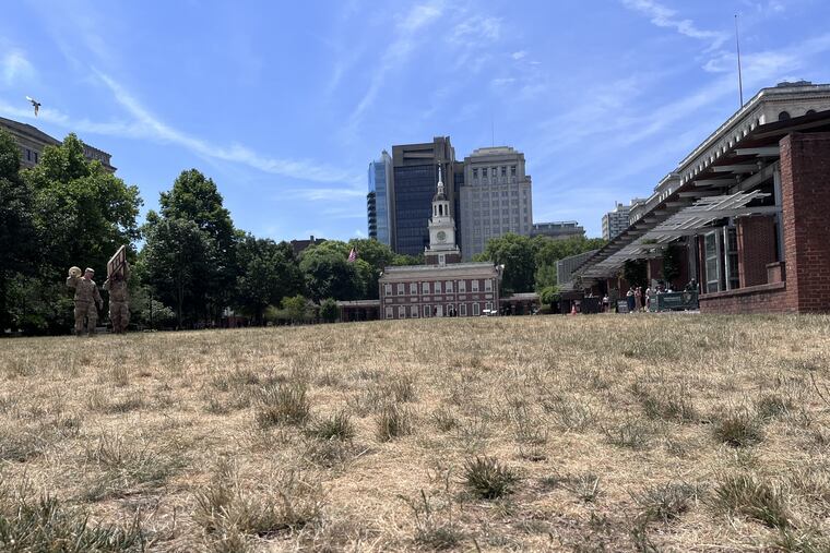
Lawns and gardens are parched and wilted — again.
As temperatures soar to dangerously high levels this week into next week, the area faces another weather bugaboo that seems headed in the wrong direction. The start of this summer on Thursday, much like last summer, was a sunbaked brown. In the words of people who watch for droughts, it is “abnormally dry” from Philly to the Shore.
One year ago, the Pennsylvania Department of Environmental Protection declared a statewide drought watch and encouraged residents and businesses to voluntarily conserve water. New Jersey experienced similar conditions. The watch was lifted for the last few counties in Pennsylvania in March after heavy storms starting in December continued through winter, bringing a surplus of rain that filled reservoirs and resulted in an abundantly green spring.
The spigot has been turned off. Consider that Philadelphia received 81% more precipitation than normal from December through April 3. Since then, the city has received only half of the amount of normal rainfall.
May saw only half the normal amount of rain for Philadelphia, according to National Weather Service data.
June is also running dry, with one single large rain of 1.87 inches recorded at Philadelphia International Airport on June 5. Yet many communities saw half of that or less from that storm. Since then, June has seen only trace amounts of scattered rain.
The forecast calls for highs in the 90s through Wednesday, with chances of reaching near 100 over the weekend and only small chances of scattered rain.
The U.S. Drought Monitor, a public-private collaborative of researchers, says parts of Delaware, Chester, Montgomery and Bucks Counties are currently all abnormally dry, a step below a moderate drought. Just about all of Philadelphia falls into the abnormally dry category, as do parts of Camden, Burlington, Gloucester, Salem and Atlantic Counties, while all of Cumberland and Cape May Counties are in that range. The range of abnormally dry areas has been spreading this week.
However, neither Pennsylvania nor New Jersey has issued a drought warning for any counties. Drought declarations aren’t based only on the amount of rain, but also on stream flow, groundwater levels, and soil moisture.
Pennsylvania, for example, issues a drought declaration only if levels depart from normal for 3 to 12 months.
So ample rain in the first quarter of the year likely has kept reservoirs and other water sources at good levels.
Larry Hajna, spokesperson for the New Jersey Department of Environmental Protection, said the state designs its water supply systems to withstand normal hot and dry periods.
“While the last 30 days have been relatively dry, the 90-day precipitation, groundwater, and streamflow trends are much closer to long-term averages,” Hajna said.
Water supply reservoirs are above 90%, an “ideal” condition for this time of year, Hajna said.
“It’s been a little bit drier than it was in the winter months,” said Joe DaSilva, a National Weather Service meteorologist.
He said a high-pressure system offshore is pumping warm air from the south into the Philly region.
“That’s what’s making it hot and dry,” he said. “It really just depends on the jet stream pattern. The upper-level jet stream has a ridge over most of the eastern third of the country right now.”
That ridge, he said, deflects storms north into Canada.
“So underneath that ridge is just dryness and heat,” DaSilva said.
In short, the Bermuda high will remain in control of Philly’s weather through the weekend. Except for two weak passing cold fronts Saturday and Sunday, high pressure systems will dominate with temperatures in the 90s through at least Wednesday. None of the cold fronts is expected to produce much rain, according to the National Weather Service forecast for the region. The best bet for rain is Sunday night, but that’s only a 60% chance. After that, there is little precipitation forecast during the extended heat wave through Wednesday.
Here’s the forecast for the next week by the National Weather Service:
Friday: Sunny, high near 96.
Saturday: Hot with a high near 98, followed by a slight chance of showers and thunderstorms.
Sunday: Hot with a high near 99, with a slight chance of showers.
Monday: High near 93, slight chance of showers.
Tuesday: A high near 92.
Wednesday: A high near 95.
Graphics editor John Duchneskie contributed to this article.