After reaching 67 degrees on Monday in Philly, some snow is possible Wednesday
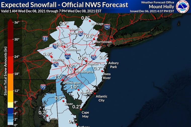
The National Weather Service says an "inch or less" is possible Wednesday. Across the country, snow has been quite scarce, with only 6% of the contiguous United States snow-covered as of Friday.
It felt a whole lot like mid-April in the Philadelphia region Monday afternoon, but snow is possible Wednesday and it might even be measurable — at least by a micrometer.
“We do have measurable snow in the forecast,” said Sarah Johnson, a lead meteorologist with the National Weather Service Office in Mount Holly, N.J., “but we don’t have much.”
Of more certainty is the prospect that the atmosphere about to remember it is December, with highs on Tuesday barely making it to 40, and likely failing to make it out of the 30s Wednesday for the first time in nine months.
An approaching front drove up the official temperature to 67 on Monday at Philadelphia International Airport, and while that was five shy of the record for a Dec. 6 of 72, it was about 18 degrees above the “normal” for the date.
After the frontal passage, temperatures were due to crash about 30 degrees overnight, and Tuesday should be a clinic in the relativity of thermal comfort. Then a weak storm is forecast to pass south of the region, and it would be cold enough for some snow if it got close enough.
Any snow would start early Wednesday, before the sun wakes up, thus it would have at least a snowball’s chance of sticking in the early going, said Paul Walker, senior meteorologist with AccuWeather Inc.
“One or two spots could pick up a couple of inches,” he said, “but most places a coating.”
And that likely would be confined to the grass and the car roofs. The National Weather Service is calling for an inch or less, if anything.
Even paltry amounts aren’t a done deal, said the weather service’s Johnson. “There’s quite a bit of uncertainty in the track.”
If snow doesn’t happen this week, it might be awhile before the region sees any winter-storm threats, with winter going on holiday perhaps until the until the Dec. 21 solstice, said Walker’s colleague, Dave Dombek. The government’s Climate Prediction Center’s two-week outlook favors temperatures above normal in much of the nation.
In fact, Walker said temperatures on Saturday could head back to the mid-60s, perhaps flirting with a record.
» READ MORE: Philly winter forecasts call for early snow, a cold December, and a 100% chance of uncertainty
So far, snow has been a scarce commodity across the country.
On Friday, snow covered only 6% of the contiguous United States, less than 20% of the average, according to the National Weather Service’s remote-sensing data, the lowest for the date since the government began keeping score in 2003.
In the early going, meteorologists say, the La Niña cooling of surface waters over vast stretches of the equatorial Pacific has been influencing weather across the United States.
Weather moves west to east, and the cooling of the overlying air over such a broad expanse of the Pacific would have impacts across North America.
The pattern is such that the Arctic air necessary to help ignite snowstorms in the midlatitudes has been largely absent. And when it has shown up, it hasn’t stayed around for long.
And conditions in the upper atmosphere over the North Atlantic favor quick movement of systems across the nation. That pattern will be very much in evidence this week.
» READ MORE: Snow is snubbing Philly in January, and February is looking mild across the nation
“It’s been very transient,” Dombek said. “You’re not locking in any cold air for any length of time. You really haven’t had any Arctic connections.”
Not that winter is over. In the period of record, a lack of national snow cover in early December by no means portends a snowless winter around here.
“It’s early,” said Dombek.
On Dec. 3, 2017, only 9.7% of the contiguous United States was covered with snow, and close to 30 inches of snow fell that winter in Philadelphia, about 8 inches above average. One of the two snowiest winters on record around here coincided with below-average snow coverage nationally in early December.
In the five years with the greatest snow coverage on Dec. 3, Philadelphia’s winter snowfall was half the longer-term average. That included 2019, when almost half the nation was blanketed with snow. Philly’s seasonal total that year was 0.3 inches.