The Jersey Shore is bracing for a big September storm — but it’s a nor’easter, not a hurricane
“Major” flooding is forecast for Saturday morning.
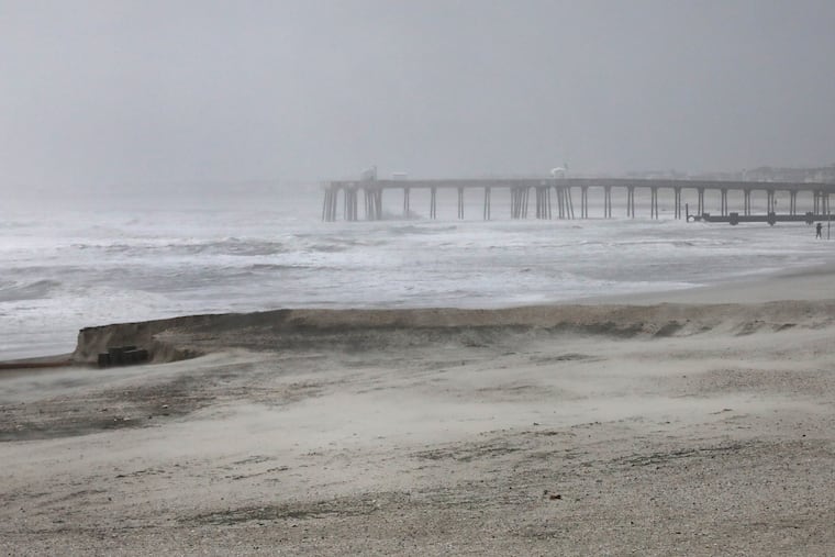
It isn’t a hurricane, or a storm with a name (at least not yet), but the early-season nor’easter that was brewing off the Mid-Atlantic coast Friday may end up focusing its ferocity on the Jersey Shore and pester the Philly area with one memorably miserable weekend.
With the storm’s projected path changing dramatically, forecasters warned Friday that heavy rains were possible throughout the weekend along with tropical-storm-force gusts that could go as high as 70 mph at the Shore. Flood warnings and advisories have been extended well into the weekend.
“Major” flooding was expected Saturday morning and possibly Saturday evening on the beachfronts and bay areas, with the National Weather Service warning “some locations may become isolated by the floodwaters.”
Up to 5 inches of rain are possible at the Shore, and as much as 4 inches in Philly.
Gov. Mikie Sherrill declared a state of emergency for the eight Shore counties, effective 5 p.m. Friday.
It is possible that the storm, which was centered about 200 miles east of Norfolk, Va., Friday morning, may make a sharp left sometime during the weekend and cross the New Jersey coast a la Superstorm Sandy in 2012, said Bob Oravec, senior branch forecaster with the federal Weather Prediction Center. (No, this won’t be in a league with Sandy, he assured.)
With storm waves pounding the oceanfront, and the back bays congested with water, multiple rounds of at least moderate flooding were expected at the Shore, and at least minor flooding along the Delaware River in Philadelphia, where winds could gust to 45 mph.
“And the full moon doesn’t help,” said Jason Franklin, the meteorologist in charge of the National Weather Service’s Mount Holly office. The monthly astronomical tug is going to exacerbate any flooding.
The timing of the storm’s impacts
A flood warning for the Shore is in effect until 2 a.m. Sunday, and minor flooding occurred with high tides Friday morning.
Significant flooding was expected for at least three consecutive high tides, which occur at roughly 12-hour intervals, on the oceanfront and the back bay abutting Ocean City starting at 7 p.m. Friday, with the major flooding Saturday morning.
On Friday, Franklin noted that the onshore winds from the Northeast — why they call them nor’easters — had taken on a more northerly direction. That would be problematic for north-facing beaches, such as the ones in North Wildwood and the north end of Avalon.
And given that the wind and gust festival was in its third day, drainage was becoming a challenge, said Franklin, particularly for the bays.
“They’re swollen,” said Franklin.
A flood advisory was up for Philly and areas along the Delaware River for minor flooding during four straight high tides beginning 1 a.m. Saturday.
The Shore was under a wind advisory until 6 a.m. Sunday, and it was possible that gusts to 70 mph could be measured along the Jersey Coast to Long Island, said Peyton Simmers, meteorologist at AccuWeather Inc.
The advisory for Philly, also in effect to 6 a.m. Sunday, called for gusts to 45 mph. On Friday, winds were gusting past 30 mph at Philadelphia International Airport, a bit friskier than they were in Atlantic City, as the storm already was having effects in the region.
But in the end the highly unusual — and very early — coastal storm could save its worst for the Jersey coast, said Oravec.
The nor’easter is early, and extraordinary
Coastal storms form along the boundaries of chilly and warm air and usually hold off until later in the fall or winter when the temperature contrasts between the cold air from the north and remnants of summer to the south ripen.
In this instance the cold air was being supplied by a powerful area of high pressure, or heavier air, over eastern Canada, whose clockwise winds from the northeast made Philly feel October-like this week.
The high’s cold winds have been interacting with the very warm waters of the Gulf Stream to generate the nor’easter and add a kick to the onshore winds, part of a cyclone’s counterclockwise circulation.
Pressure differences incite winds: A common image is that of air from a punctured tire rushing into air that is half as light.
One subplot to watch is that the nor’easter may take on tropical characteristics, drawing moisture and warmth from spending so much time over the Gulf Stream, said Simmers. That could bump up the rain amounts.
It could even become a “subtropical storm,” he said, although he wouldn’t expect the National Hurricane Center to name it. Not that the distinction would make much difference.
Nor’easters vs. Hurricanes
The U.S. East Coast happens to be one of the world’s favored spawning grounds for cyclones, notes John Gyakum, an atmospheric scientist at McGill University in Montreal who is an expert in coastal storms.
Unlike hurricanes, which form in the tropics, nor’easters develop in the cooler midlatitudes.
Hurricanes tend to be more destructive and have more celebrity power, but their influence is relatively small compared with nor’easters, whose circulation can cover thousands of miles. Also, nor’easter winds can persist for days, eroding beaches and causing significant property damage. Hurricanes tend to be quick hitters.
A coastal storm that coincided with a full moon and five consecutive high tides in March 1962 caused mass devastation and forever changed the New Jersey Shore. One of the most destructive nor’easters in the period of record was the Blizzard of March 1993, which affected areas from Florida to Maine and as far west as Illinois.
Sandy technically was a hybrid storm, losing its tropical characteristics after it made landfall in October 2012 near Atlantic City and buzz-sawed west, knocking out power to more than a million electric customers.
This nor’easter will be no Sandy, but for celebrity power, it won’t be competing with any hurricanes. Not a single one has formed this season, an unprecedented wait for a first hurricane.
No complaints have been registered among residents or property owners along the Gulf or Atlantic coasts.